Revisiting Moab

Moab is one of my favorite places on planet Earth, well the entire Solar System really. Jason and I just made our biannual trip to its weather-sculpted plateaus and untouched deserts that feel a bit like home to us…a home with an infinite crawl space. We spent three days seeking out adventure in its unexplored routes and novel crevices. Seek and ye shall find fun, or so I hear.

The switchbacks descending into Mineral Bottom seemed never ending on the way down and a lot more never ending on the way back up.

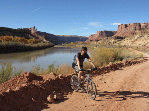
The hype surrounding the White Rim Trail has always made Jason and me curious…and skeptical. This 100-mile-long 4WD road below the Island in the Sky District of Canyonlands National Park could possibly be the most popular scenic ride anywhere. Between the 4WDs, dirt bikes and mountain bikes, it apparently becomes a crammed freeway during peak season. Experiencing the marvels of “peaceful solitude” alongside throngs of people? No thanks. That’s why Jason and I thought we’d give this famous path a try while the nature-obsessed hordes were absent thanks to the nearness of winter. We only saw a couple of 4WDs and a handful of bikers our entire day on the rim. Hallelujah for November!

Jason took this picture of me from one switchback up. It looks like an aerial shot.
The White Rim Trail practically jumps into the Green River.

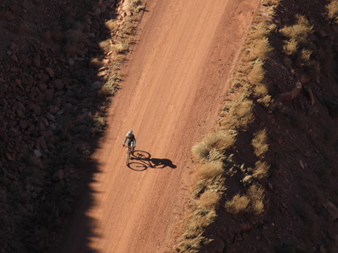
We accessed the White Rim via Mineral Bottom Road, hopping on our bikes right before this path plunges to the actual bottom of Mineral Bottom over a series of gnarly switchbacks. We sped past the remains of four or five cars that had probably dived over the side of this narrow thoroughfare many years ago. Unsettling. Once we finished our descent to the river, our journey became practically effortless. White Rim is neither technically challenging nor physically difficult, apart from the brutal climb necessary to emerge from its bottom. In fact, I would venture that it’s the easiest trail we’ve ever done in Moab.

The weather was pleasant in Moab but extra layers were necessary off and on. I got sick of pulling off and on my warm warmers so in a ridiculous halfway-state they stayed.
The weather was pleasant in Moab but extra layers were necessary off and on. I got sick of pulling off and on my arm warmers so in a ridiculous halfway-state they stayed.

Was it worthy of all the hype? Not really. Towering plateaus with odd-shaped crowns encircled us and the Green River nonchalantly sprawled out at our feet surrounded by a halo of yellowing leaves but, as ideal as that setting sounds, the scenery was not any prettier than some we’ve witnessed at other less-acclaimed locations. With the seclusion we enjoyed that day, this ride was well worth it but would it be worth it in the presence of an endless caravan of tourists bent on experiencing the “wilderness”? Absolutely not. There are plenty of gorgeous places around Moab where you can enjoy nature’s exquisiteness without nature’s plague, AKA man.

This beautiful overlook on the Portal Trail marked the beginning of the ill-advised portion of the path.
Signs such as this were posted at several points on the Portal Trail.

Thanks to the time change, we only had enough daylight to bike a little over 20 miles of the White Rim but, with the 1000-foot ascent out of Mineral Bottom squished into a fraction of a mile, we got a hardy workout anyway.

Do you see a path in the middle of this cliff? No? There is one: the perilous Portal Trail.

Our second day in Moab is traditionally our hiking day. We give our sore butts a brief breather and use our feet for something besides pedaling. This time we packed our hiking day with not one but two adventures. First, we hit the infamous Portal Trail. Why is it infamous you ask? For starters, it’s one of the most dangerous trails in the world and has claimed the lives of three bikers. This route is a thousand feet up from the valley floor and right, and I mean right, on the edge of a 200-foot cliff. A three-foot ledge between the precipice above and the precipice below is all you’ve got to travel on and, believe me, it’s not much. It was scary enough just walking it, I can’t imagine the level of derangement necessary to consider biking it. The views of the Colorado River, too far below, were amazing but I found myself hugging the path while those precarious heights made me a little woozy. Beauty and terror: sounds more like your typical dating scene than a leisurely trip down a little portal.

False Kiva is tucked away in a hidden cave on the side of a rock face.
The area around Moab has so much geological diversity that the terrain looks completely different from one spot to the next.

After our 5-mile trek through the Portal of Death, Jason and I went on a different kind of adventure, the secret kind. False Kiva, so named because its origins are unknown, is a round stone structure built in a remote cave in the Island in the Sky District of Canyonlands National Park. Don’t bother looking for a trail to it on your park map, you won’t find one. While the 1.6-mile route to the kiva is pretty well-marked, the debate on whether to disclose the exact location of this archeological site has never been resolved and so it remains semi-concealed. We had a great time wandering the hush-hush path to this cave and photographing its cryptic kiva. Nothing makes something more fascinating than a secret.

These nameless precipices provided an excellent viewpoint from which to gawk at the Book Cliffs.
The ride to the Book Cliffs overlook crossed a steep tongue of slickrock.

Our last day in Moab we decided to divert from the beaten path even more than usual and take a little-known 4WD trail up to an obscure viewpoint overlooking the Book Cliffs. The Book Cliffs are the longest continuous escarpment in the world, traveling through a hundred miles of Utah and Colorado. The path we rode to “view” them was a little less than six miles total but it was so swathed in loose stones that it took us three hours to complete this outing. Although the panoramas of the Book Cliffs from the overlook were splendid, we found the unnamed precipices that the overlook itself was located on to be more interesting. We paused for an awesome snack break on their brink above Salt Valley’s beautiful desolation. What a nice, although rocky, little jaunt.

The "road" to the Book Cliffs overlook was as rocky as they come and very tricky to ride.
The “road” to the Book Cliffs overlook was as rocky as they come and very tricky to ride.

Moab, our favorite nature-made playground, again proved itself superior to any manufactured monkey-bars. We tired ourselves out pedaling its rimmed plateaus, discovered a few of its guarded secrets and witnessed some of its greatest dangers. It’s hard to cram that much intrigue into three days but somehow we managed.

The Maine Attraction Part II: Inland

Last week I shared my maritime tales of Maine’s shoreline and now allow me to follow up those salty stories with the details of our journey into the scenic core of New England.

Bethel, a small Maine village of 2,500 residents nestled near the New Hampshire border, was our first inland stop. Jason and I strayed from our comfort zone a bit and stayed at a little B&B while in this tiny hamlet. The building was over 100 years old and its age showed. The floors squeaked and the doorknobs didn’t turn so well but there was a feeling of significance in that vintage dwelling. The innkeepers were very hospitable and cheerily made us a delicious breakfast each morning using eggs from their own happy chickens. Sometimes comfort zones are for sissies.

The Artist's Bridge near Bethel is the most photographed or painted covered bridge in Maine. It was easy to imagine the Headless Horseman waiting at its end, pumpkin in hand.
The Artist’s Bridge near Bethel is the most photographed and painted covered bridge in Maine. It was easy to imagine the Headless Horseman waiting at its end, pumpkin in hand.

Like our B&B, every part of Bethel spoke history. It was full of antique church spires and homes not much younger than America. Its widespread white clapboard buildings and village greens were lovingly preserved and just plain lovely.

We came across Step Falls unexpectedly. What a nice surprise.
Table Rock in Grafton Notch State Park became our lunch table.

Bethel’s charm wasn’t its only appeal though. It was conveniently close to Grafton Notch, a U-shaped valley carved out by glaciers, which we were eager to explore. Glaciers receded from New England about 14,000 years ago yet their icy influence can still be seen in its rounded mountaintops and pitted rock. Potholes in this region, sculpted by glacial debris, have turned the streams cascading down them into nature’s waterslides over the millennia. These acrobatic rivers frequently twist and jump across their granite platforms, performing a continuous magnificent show.

Screw Auger Falls plummets 30 feet into a granite gorge.

In the Grafton Notch area we saw a couple such jumps, Screw Auger and Step Falls, and took a hike through some of the oddest terrain I’ve ever stood on. Table Rock, a giant block of granite, was our 2.4-mile destination. To get to it we had to climb a never-ending flight of roughly-hewn rock steps. These giant “stairs” only ceased when the terrain became a jumble of massive boulders, which had to be leapt and scrambled over. Although strenuous, this trek was quite fun and the fantastic views of the Mahoosuc Range from Table Rock would have been worth it regardless.

Not all of the leaves were changing yet in Stowe but splashes of color were everywhere.

Upon leaving Bethel, we proceeded west to Stowe, Vermont, famous for its ski resorts and fall leaves. We paused as we passed through New Hampshire to do a short hike in Moose Brook State Park. Our little walk followed Perkins Brook through a quiet mossy forest. The spongy soil was peopled with mushrooms and anything that hadn’t moved recently was covered in swaths of flourishing life. The dappled light filtering through the emerald canopy doubled the green of the ground and brought to mind the realm of fairies.

The road up Smugglers' Notch was tiny, twisty and lined with boulders.
The road up Smugglers’ Notch was tiny, twisty and lined with boulders.
Although our visit did not coincide with "peak" fall foliage, all around us intense reds, yellows and oranges mixed with the green leftovers of summer.
Although our visit did not coincide with “peak” fall foliage, all around us intense reds, yellows and oranges mixed with the green leftovers of summer.

After that brief intermission, we continued on our way to Stowe, a beautiful drive. The Vermont countryside was dotted with bright weathered barns and hilly pastures, which the dense forests just beyond seemed plotting to reclaim. Stowe was made of the same scenic stuff. In the shadow of Mt. Mansfield, Vermont’s highest peak, this quaint little village looked like it hadn’t changed much in many years.

The Basin on the Pemigewasset River was created by glacial erosion.
The "Dream Cottage" at Sugar Hill Inn lived up to its name.
The “Dream Cottage” at Sugar Hill Inn lived up to its name.

While at Stowe we hiked in nearby Smugglers’ Notch, so called because it’s been a favorite route for sneaking alcohol, people, you name it, into and out of Canada throughout American history. The trails we took to Bingham Falls and Sterling Pond were stunning but crossed by rivulets and trickles so often it seemed that the whole area was part of some makeshift waterway. Along with the views we encountered by using our feet, we caught a ride on the Stowe Mountain Resort gondola and got a cheater’s peek of the panorama from the top of Mt. Mansfield.

The Baby Flume was just another interesting Franconian backdrop created by water and stone.

Our visit to Stowe’s happened to be the same weekend as their annual British Invasion, a regional British-car show. After gorging on fantastic dinner fare one night, we decided to drive into town but found the road blocked off for the “British Invasion Block Party.” Stowe’s main street was lined with tiny English sports cars and people eating ice cream cones and generally having a good time. We thought we might as well have a good time too so we took to mingling with the jovial throngs. A band was playing some classic rock tunes and soon the crowd started boogying and swinging to the music. Everyone, from children so young they could barely walk to gents so old they could barely walk, joined in the fun. Jason and I also took to grooving on the pavement. Thus, we connected with that friendly community on their small street with the full moon and historic steeples floating above us. It truly felt like something out of a movie.

We made it to these cascades in Franconia Notch State Park right as a brooding mist settled over us, giving the scenery a supernatural quality.
This little cascade near The Basin seemed to hold a secret that could only be heard in the rustling whisper of the dancing fallen leaves.

The last stop in our inland interlude was Franconia, New Hampshire. Franconia, in the midst of the White Mountains, is definitely a blink-and-miss town but enchanting nonetheless. While we didn’t find the foliage in Stowe as impressive as we’d hoped, due to the earliness of the season, the woods around Franconia were smack in the middle of their fall fire. The whole area was ablaze and gorgeous.

This stream of water slid through worn stone like a zigzagging ghost.

We stayed in the “Dream Cottage” at the Sugar Hill Inn our night in Franconia. With a giant fireplace, private sauna and comfy porch swing, it’s a shame we couldn’t just spend the evening slouching in our bungalow but Franconia Notch State Park was not to be missed. This notch’s rugged beauty inspired authors like Nathaniel Hawthorne and Henry David Thoreau. It inspired us too. Oddly enough, sometimes inspiration feels a lot like a downpour. We hiked to various falls and features along the Pemigewasset River as rain pelted us through an eerie blanket of mist. It was surreal yet soggy.

The poet Robert Frost spent five years and twenty summers at a farmhouse that overlooks the Franconian mountains. We visited it.

Before we headed to Boston to catch our flight the next day, we stopped at Frost Place, home of the poet Robert Frost for five years and twenty summers. The spectacular views of the Franconia Notch from his modest farmhouse made Frost’s wooded muses almost tangible.

Flume Gorge is an 800-foot-long gap with narrow granite walls.

Although time wasn’t really permitting, after Frost Place we hurriedly explored Flume Gorge, an 800-foot-long chasm created by a plume of lava squishing through a crack and then eroding. I wish we could have enjoyed its lush sheer walls and impressive falls without time constraints but seeing it in a dash was better than not seeing it at all. We rushed back to Boston after our gorge tour with just enough time to not feel panicked about making our flight. Whew!

Avalanche Falls hurls water 25 feet down Flume Gorge.

New England may not be a common vacation destination for those in the west but Jason and I are very glad we’ve roamed its precipitous shores and saturated woods. Compared to visiting Maine and its neighbors, all other holidays are minor.

The Maine Attraction Part I: the Coast

The company that Jason works for pays for him and his family (i.e. me) to go on a vacation once a year. We had a hard time narrowing down where we wanted to go for 2013. In the end, we decided on a part of the United States that we had never visited but had always wanted to: Maine, Vermont, and New Hampshire. New England’s charm, beautiful coastline and vibrant fall foliage was a salty recipe for retreat that we couldn’t resist taking a bite of.

Portland Head was commissioned in 1790 by George Washington. It's Maine's oldest lighthouse.
Portland Head was commissioned in 1790 by George Washington. It’s Maine’s oldest lighthouse.
The lobster shack by the Cape Elizabeth lighthouses had the best lobster I've ever eaten and probably ever will.
The lobster shack by the Cape Elizabeth lighthouses had the best lobster I’ve ever eaten and probably ever will.

New England is a big chunk of land with lots to keep your eyes and feet occupied so choosing where to spend our time was not easy. I read a 400-page travel book as I puzzled over this quandary and researched a whole lot on Trip Advisor. Our friends were no help as none of them have ever been to this region but I think I sorted out a pretty good itinerary for our excursion without the assistance of acquaintances.

Cape Elizabeth's twin lights weren't open to the public but they were still pretty from afar.
Cape Elizabeth’s twin lights weren’t open to the public but they were still pretty from afar.
I wish we could have spent more time at the Inn at Sunrise Point. It was a tranquil and pretty place.

We flew into Boston and began traveling up the coast, staying our first night in Portland, Maine. We found Portland, Maine’s only real city, quaint and historic. Whiffs of briny air hit us now and then as we wandered through the cobblestone streets of its Old Port district and took in the scenic shoreline from its Eastern Prom Trail. Delightful.

The "sand" on Sand Beach is mostly composed of the remains of marine life. Graveyards don't usually look this nice.
The “sand” on Sand Beach is mostly composed of the remains of marine life. Graveyards don’t usually look this nice.
The Ocean Path Trail wound through one gorgeous vista after another.

While in that town we toured the magnificent Victoria Mansion, circa 1858, widely regarded as the most ornate dwelling from its time period left in the country. Beyond exploring that spectacular building, we couldn’t leave Portland without also checking out its famous lighthouses: Portland Head and the twins of Cape Elizabeth. Lighthouses in Maine? Funny you should ask. Maine’s shores are guarded by 66 lighthouses, 52 of which are still in working order. Why so many? The coast of this state is more hazardous than most. Rocks + fog = ship booboo = sad panda. It’s easier than algebra. Although somewhat antiquated with today’s newfangled technologies, lighthouses still service small watercraft and conjure romantic notions of a tough solitary existence. In short, when in Maine, visiting at least a few of these steadfast beacons is practically mandatory.

Just another candid moment.
Thunder Hole, a naturally-formed inlet, was so named because of the roaring sound trapped air makes each time a wave crowds in.
Thunder Hole, a naturally-formed inlet, was so named because of the roaring sound trapped air makes each time a wave crowds in it.

After leaving Portland, we stopped in Freeport to visit L.L. Bean’s flagship store, a strange request of Jason’s, and check out a few other shops that featured local handmade pottery and jewelry. (Yes, I did purchase some. Do you really need to ask?) Then, we settled in for the evening near Camden at the Inn at Sunrise Point. Don’t let the “inn” in that name mislead you, we were really staying at a private cottage on the beach. Ahhhhh. Our “Rachel Carson” cottage was lovely: a giant wall of windows looking out over the ocean, a porch with wicker rockers to encourage relaxation, a gas fireplace and a monstrous jetted tub. Following our arrival, we walked along its rock-strewn beach under the dreamy light of the nearly-full moon and then cozied up by our fireplace with good books. After that thorough unwinding, we cracked our windows just enough that a refreshing ocean breeze drifted in as the rhythmic pulsing of the waves carried us off to sleep.

The red sun hitting the pink cliffs below Bass Harbor lighthouse created this blaze of color.
The red sun hitting the pink cliffs below Bass Harbor created this blaze of color.
Taking pictures was one of my favorite pastimes on this trip. The area's dramatic shorelines and cascading flows provided endless subjects matter.
Taking pictures was one of my favorite pastimes on this trip. The area’s dramatic shorelines and cascading flows provided endless subjects matter.

As for Camden, a classier and more charming New England village you will not find. Before we continued on our way north, we took a little time to stroll its picturesque streets and catch an aerial view of the surrounding bay from Mount Battie, a 780-foot verdant outcropping that gently rises behind Camden’s pleasing avenues.

The fiddler on the roof? No, just Jason on the rocks below Bass Harbor Head Light in the near-night
The fiddler on the roof? No, just Jason on the rocks below Bass Harbor Head Light in the near-night.
Leave it to Jason to capture this moment of contemplative entrancement.

Too soon we were moving north again or, as the locals put it, Down East. After a couple of detours to check out the Fort Point lighthouse and fatten ourselves further with lobster rolls from yet another waterside shack, we arrived at our last coastal destination: Bar Harbor. Bar Harbor, located on Mount Desert Island just outside Acadia National Park, has an outdoorsy touristy feel that caters to the wannabe-naturalist crowd but it’s still a cute town. In Bar Harbor we gobbled some of the best ice cream I’ve ever eaten, however, we spent most of our non-gorging hours inside Acadia, America’s second-most visited national park. With lush forests rimmed by cliffs of pink granite that plunge into the ocean, it’s easy to see why Acadia attracts 2 million visitors each year. Since our time was limited, we had to choose wisely which of its 125 miles of trail options to hit. It was difficult but I believe even that last knight of the Crusades would be proud of our decision.

The Bass Harbor lighthouse was truly a photographer's dream. I got over ten mosquito bites on my feel while trying to capture its descent into darkness but I didn't even notice.
The Bass Harbor lighthouse was truly a photographer’s dream. I got over ten mosquito bites on my feet while trying to capture its descent into darkness but I didn’t even notice.
The sun and I have a precarious relationship; no matter how much I love it, I always end up getting burned. Still, it felt right to welcome it to a new day from on top of Cadillac Mountain, it being the star and all.
The sun and I have a precarious relationship. No matter how much I love it, I always end up getting burned. Still, it felt right to welcome it to a new day from on top of Cadillac Mountain.

We walked the Ocean Path Trail, a 4.4-mile stroll along Acadia’s jagged coastline, our first day in the park. It was a mellow and beautiful meandering. The following morning we set sleep and mellow aside to embark on some sunrise madness. Cadillac Mountain, at a whopping 1,530 feet, is, oddly enough, the tallest peak on the Eastern Seaboard north of Brazil. (No snickering please Utahans.) Because of its eastern location and height, it’s the first place in the country to see the break of day each morning. It’s a longstanding tradition among tourists and locals alike to greet the rising sun from atop Cadillac’s rounded dome and, hence, be one of the first in the country to see a new dawn. Jason was a little reluctant to get up at 4:55 AM (2:55 back home) to greet anything but he gave in to my enthusiasm and, thus, we found ourselves out in 37 degrees with the wind hustling around us as we waited for the arrival of that glowing orb. It was bitterly cold but I’d like to think it was worth it…I’m pretty sure it was.

For how short the South Bubble is, climbing it supplied a surprising amount of exercise and adventure.
Scaling rungs and squeezing into crevices was required to reach the top of the South Bubble. Awesome!

Since we were already up, I convinced Jason that we might as well hike to the top of another mountain. He was a little resistant to this plan but he eventually caved to my stubbornness. (Are you seeing a pattern here?) I only had to wear a beanie, gloves, a sweater and three jackets to stay marginally warm as we made our way up the South Bubble. You westerners might laugh a little about me even calling the South Bubble a “mountain” since its summit is only 766 feet above sea level but, apparently, that’s what it technically is. Our chilly jaunt was too early and frigid for all but the senseless and stupid so we saw absolutely no one on the Bubble and only ran into other wanderers as we neared the last curves of Jordan Pond, a deep glacier-made lake that we circled to reach our “mountain.”

Bubble Rock was dropped by a melting glacier 15,000 years ago.
Much to Jason's delight, I am always willing to be a photo's fool.
Much to Jason’s delight, I am always willing to be a photo’s fool.

And, thusly, we ended our time on the coast and began our trek inland. I will save our adventures in New England’s interior for next week. I wouldn’t want to add too much excitement or too many thoughts of lobster to your lives.